


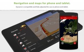
Dynavix Navigation & Cameras
คำอธิบายของDynavix Navigation & Cameras
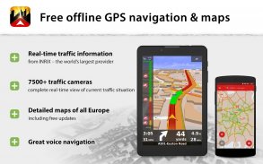
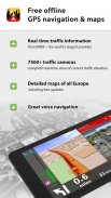
+ การนำทาง GPS ออฟไลน์ฟรีสำหรับ Android พร้อมฟังก์ชันอัตโนมัติของ Android
+ อัปเดตข้อมูลแผนที่ตลอดอายุการใช้งานฟรีปีละหลายครั้ง แผนที่จะถูกจัดเก็บไว้ในอุปกรณ์ของคุณและสามารถใช้ได้ทุกที่ทุกเวลา
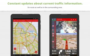
+ กล้องจราจรแบบเรียลไทม์ช่วยในการแนะนำเส้นทาง
________________________________________________
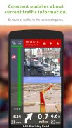
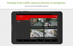
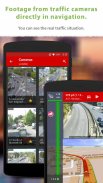
ภาพรวมจากกล้องจราจรออนไลน์ใกล้กับเส้นทางที่วางแผนไว้:
มีเพียง Dynavix เท่านั้นที่ให้คุณดูข้อมูลจากกล้องจราจรที่อยู่รอบเส้นทางที่คำนวณได้ นอกจากนี้ Dynavix ยังช่วยให้คุณสร้างรายการกล้องแบบกำหนดเอง การดูข้อมูลจากกล้องในแผนที่ และคุณสมบัติอื่น ๆ ปัจจุบัน Dynavix รองรับการเข้าถึงกล้องจราจรมากกว่า 7,500 ตัวทั่วยุโรป
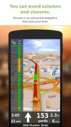
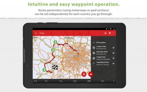
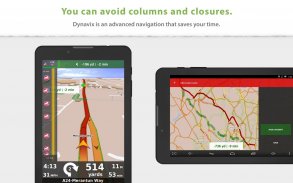
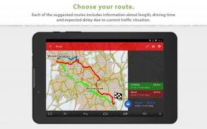
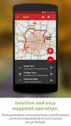
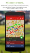
การวางแผนเส้นทางขั้นสูงโดยใช้เวย์พอยท์:
Dynavix ใหม่ยังปรับปรุงการวางแผนเส้นทางอย่างมากด้วยการใช้เวย์พอยท์ ขณะนี้การวางแผนมีความชัดเจนและปรับใช้บนโทรศัพท์มือถือและแท็บเล็ตแล้ว
แผนที่ที่แม่นยำคุณภาพสูง:
Dynavix ใหม่ใช้ข้อมูล OpenStreetMap เราเชื่อว่าจุดแข็งของชุมชนระหว่างประเทศและแนวปฏิบัติในปัจจุบันแสดงให้เห็นว่า OpenStreetMap มีรายละเอียดมากและมักจะดีกว่าแผนที่จากผู้ให้บริการรายอื่น
ฟังก์ชันหลักของ Dynavix:
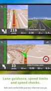
• การนำทางด้วยเสียงแบบออฟไลน์แบบเลี้ยวต่อเลี้ยว
• มุมมองจากกล้องจราจรออนไลน์ใกล้เส้นทางที่วางแผนไว้
• อัปเดตแผนที่ฟรีตลอดอายุการใช้งานปีละหลายครั้ง
• การเชื่อมต่ออัตโนมัติของ Android
• การวางแผนเส้นทางขั้นสูงโดยใช้จุดอ้างอิงที่มีความเป็นไปได้ที่จะหลีกเลี่ยงถนนที่เก็บค่าผ่านทางในบางประเทศหรือตลอดเส้นทาง
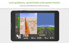
• ระบบช่วยเปลี่ยนเลนและป้ายทางหลวง
• ค้นหาที่อยู่ข้อความแบบเต็ม
• เส้นทางทางเลือก
• รองรับคำสั่งเสียงผ่านแฮนด์ฟรี Bluetooth (โหมดมีเดียหรือการโทร)
• สถิติการเดินทางพร้อมส่งออกไปยัง *.csv ได้
• ฐานข้อมูลขนาดใหญ่ของจุดสนใจ
• มุมมองแผนที่ 2D / 3D
• การแจ้งเตือนการตรวจสอบความเร็ว (พร้อมความเป็นไปได้ในการนำเข้าเรดาร์ฐานข้อมูลชุมชน)
• คำเตือนจำกัดความเร็ว
• ระบบนำทางสำหรับคนเดินเท้า
• ปรับแต่งตัวเลือกมุมมองที่หลากหลาย
แผนที่ (เก็บไว้ในหน่วยความจำอุปกรณ์):
ยุโรป
แอลเบเนีย อันดอร์รา เบลารุส บอสเนีย-เฮอร์เซโกวีนา บัลแกเรีย โครเอเชีย สาธารณรัฐเช็ก ออสเตรีย เบลเยียม เดนมาร์ก เอสโตเนีย ฟินแลนด์ ฝรั่งเศส เยอรมนี ยิบรอลตาร์ กรีซ ฮังการี อิตาลี ไอร์แลนด์ ลัตเวีย ลิกเตนสไตน์ ลิทัวเนีย ลักเซมเบิร์ก มอลตา , มาซิโดเนีย, มอนเตเนโกร, โมนาโก, เนเธอร์แลนด์, นอร์เวย์, สโลวาเกีย, สโลวีเนีย, สเปน, โปแลนด์ โปรตุเกส, โรมาเนีย, ซานมารีโน, เซอร์เบีย, สวีเดน, สวิตเซอร์แลนด์, ตุรกี, สหราชอาณาจักร, นครวาติกัน
ข้อมูลการจราจรมีให้บริการในประเทศต่อไปนี้:
สาธารณรัฐเช็ก, เบลเยียม, เนเธอร์แลนด์, เยอรมนี, สวีเดน, สหราชอาณาจักร
อเมริกาเหนือ
สหรัฐอเมริกา, แคนาดา
________________________________________________
สำหรับข้อมูลเพิ่มเติมโปรดเยี่ยมชมเว็บไซต์ของเราที่ www.dynavix.com
หากคุณชอบการนำทาง Dynavix เราขอแนะนำให้คุณเขียนบทวิจารณ์สั้นๆ เป็นอย่างน้อย
หมายเหตุ:
• การนำทางสามารถลดอายุการใช้งานแบตเตอรี่ได้อย่างมากแม้จะทำงานในพื้นหลังก็ตาม ตรวจสอบให้แน่ใจว่าคุณเชื่อมต่อโทรศัพท์กับเครื่องชาร์จเมื่อใช้การนำทาง
• จำเป็นต้องมีการเชื่อมต่ออินเทอร์เน็ตเพื่อใช้ข้อมูลการจราจรแบบเรียลไทม์
Dynavix Navigation & Cameras--เวอร์ชั่น6.6.29
(08-10-2024)Dynavix Navigation & Cameras - ข้อมูล APK
เวอร์ชั่น APK: 6.6.29แพ็คเกจ: com.dynavix.navigationเวอร์ชั่นล่าสุดของDynavix Navigation & Cameras
เวอร์ชั่นอื่น


แอปในประเภทเดียวกัน

คุณอาจจะชอบ...


